
Last Updated on October 17, 2026
Some of Europe’s best sights are found beyond its major cities. Mountain roads lead to small villages, train routes wind through scenic valleys, and coastal drives link historic towns to beaches and viewpoints. Exploring more than one region can reveal a side of a country that’s easy to miss when you stay in one place.
A multi-stop trip gives independent travelers the freedom to explore well-known attractions while making time for lesser-known places along the route. These five countries are particularly well suited to exploring on the move, with landscapes, towns and scenic routes that make traveling between destinations part of the experience.
Following Cliff Edges and Offshore Islands Along the Wild Atlantic Way, Ireland
Ireland’s Wild Atlantic Way follows the western coastline from County Donegal to Kinsale in County Cork, passing sea cliffs, sandy coves and fishing towns. In Donegal, the Slieve League cliffs rise high above the Atlantic, while farther south, Connemara’s mountains and boglands give way to the limestone landscape of the Burren. The changing scenery makes the journey worth breaking into shorter stretches.
In County Clare, the Cliffs of Moher overlook the Atlantic, with views towards the Aran Islands on clear days. Nearby Doolin is a popular stop for traditional Irish music, while the Slea Head Drive on the Dingle Peninsula passes Coumeenoole Beach and viewpoints overlooking the Blasket Islands. Farther south, the Ring of Kerry winds through coastal villages, including Waterville and Sneem.
From Doolin, ferries reach the Aran Islands, where Irish-speaking communities and stone-walled fields show a different side of Ireland’s west coast. Seasonal ferries from Dunquin also run to Great Blasket Island, where abandoned cottages recall the community that left in 1953. Visitors can explore the coastline independently by car, stopping at villages and viewpoints along the way. For those who prefer a guide, traveling on small group tours of Ireland is another way to learn about the region’s history and local traditions.
Passing Terraced Vineyards and Wine Quintas in the Douro Valley, Portugal
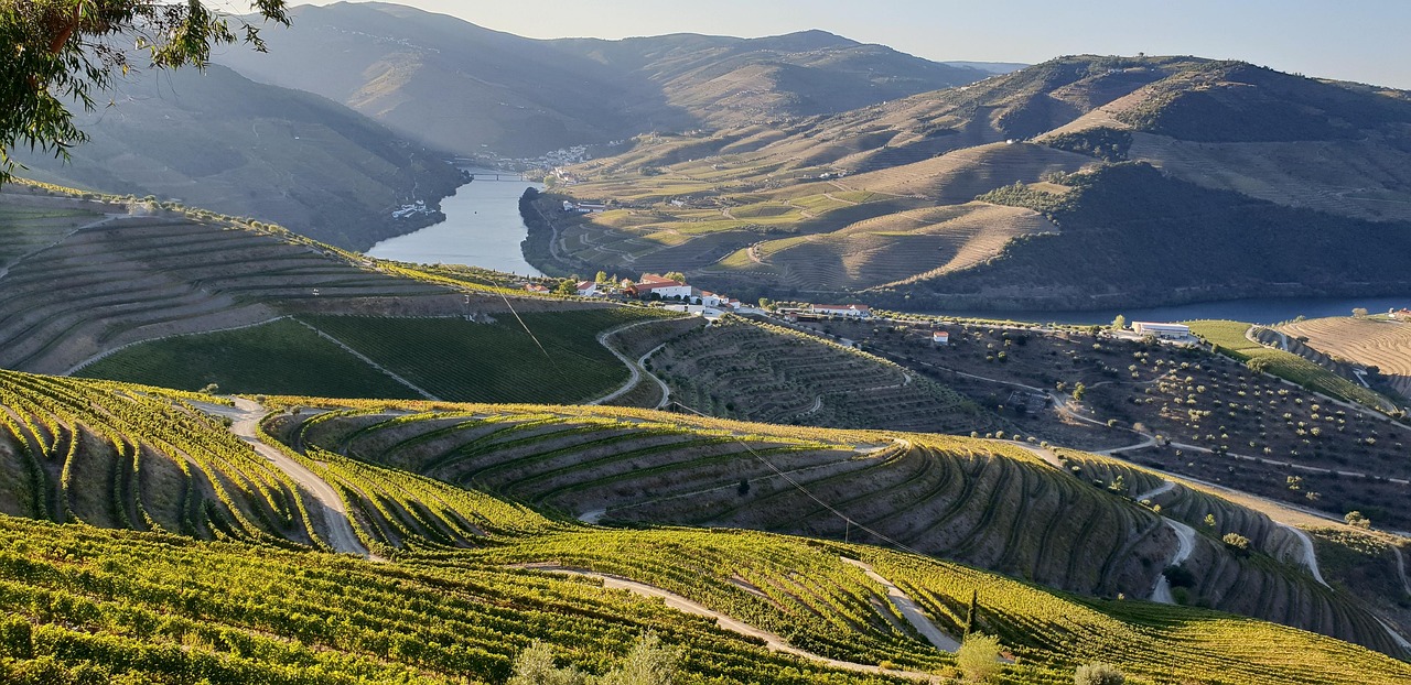
Portugal’s Douro Valley is a landscape of steep hillsides covered in terraced vineyards, with the Douro River winding between them. The N222 between Peso da Régua and Pinhão follows the river past small villages and stone-walled terraces, with bends that reveal views across the valley. Centuries of winemaking have shaped this UNESCO-listed landscape, where vineyards stretch across slopes rising high above the water.
In Pinhão, the railway station is worth visiting for its blue-and-white tile panels depicting traditional vineyard life. A short drive uphill leads to the Casal de Loivos viewpoint, overlooking the river and surrounding terraces. Boat trips from Pinhão provide another perspective on the valley, recalling the days when traditional rabelo boats carried barrels of Port wine downstream towards Porto.
Traveling through the region by car makes it easier to visit hillside villages like Provesende and Favaios, while the Douro railway is a scenic alternative for those who prefer not to drive. Along the way, several wine estates, known locally as quintas, welcome visitors for cellar tours and tastings. Spending a few days exploring the valley leaves time for riverside walks, village stops and discovering the region’s winemaking traditions.
Crossing Alpine Passes and Mountain Lakes in the Central Alps, Switzerland
Switzerland’s mountain roads wind through valleys bordered by rocky peaks, glaciers and alpine meadows. The Susten Pass climbs from Wassen through the Meien Valley before descending towards Innertkirchen, with views of the Steingletscher glacier along the way. Farther south, the Furka Pass crosses rugged mountain terrain above the upper Rhône Valley, with hairpin bends and viewpoints overlooking the surrounding peaks.
Beyond the high mountain passes, there is plenty to explore, from lakeside towns to alpine villages. Lake Lucerne’s waterfront promenades contrast with the turquoise waters of Lake Brienz, while Grindelwald has hiking trails and cable cars beneath the Eiger. Farther south, Zermatt offers views of the Matterhorn and can be reached by train from Täsch, where visitors arriving by car must park.
Independent travelers can explore the mountain roads at their own pace, stopping at viewpoints and villages along the way. The Susten and Furka passes typically close during winter, so seasonal access is important when choosing 7 day Switzerland tours or planning a self-drive route. Switzerland’s rail network also makes it possible to connect many towns and mountain resorts without a car.
Tracing Roman Ruins and Renaissance Fortresses Along the Dalmatian Coast, Croatia
Croatia’s Dalmatian coast stretches between the limestone mountains and the Adriatic Sea, with islands, pebble coves and historic towns along the way. The Jadranska Magistrala coastal road winds south from Zadar towards Dubrovnik, passing through Šibenik, Split and the scenic Makarska Riviera. Along certain stretches, the road climbs above the shoreline, revealing views of offshore islands and sheltered bays below.
In Šibenik, narrow streets lead to the Cathedral of St James, while the 16th-century St Nicholas Fortress stands at the entrance to St Anthony’s Channel. Further south, Split’s historic center has grown around the remains of Roman emperor Diocletian’s Palace, where ancient stone walls now surround shops, cafés and residential streets. Dubrovnik is another highlight, with its medieval city walls overlooking terracotta rooftops and the Adriatic.
Island visits add another dimension to the coastal journey. Ferries from Split connect with Stari Grad on Hvar, while a crossing from Orebić on the Pelješac Peninsula reaches Korčula, known for its walled old town. Travelers can combine these island trips with coastal drives or use buses and passenger ferries to connect the main destinations. Checking ferry schedules in advance is particularly useful outside the summer season.

Circling Waterfalls and Glaciers on the Ring Road, Iceland
Iceland’s Ring Road, also known as Route 1, circles the island past lava fields, coastal plains and glacier-covered mountains. On the south coast, the drive from Reykjavík towards Vík passes Seljalandsfoss and Skógafoss waterfalls, with walking paths and viewpoints near each. Just outside Vík, Reynisfjara’s black sand and basalt columns reveal another side of the volcanic landscape.
Further east, Jökulsárlón glacier lagoon holds icebergs that break away from Breiðamerkurjökull, an outlet glacier of the Vatnajökull ice cap. Some pieces drift out to sea and wash onto nearby Diamond Beach, where the ice contrasts with the black volcanic sand. Beyond Höfn, Route 1 continues through the Eastfjords, where fishing towns sit beneath steep mountains and the road curves around narrow inlets.
In northern Iceland, the Lake Mývatn area is known for its lava formations and geothermal sites, including the steaming mud pools at Hverir. The route also passes Goðafoss waterfall before reaching Akureyri. Allow at least a week for the full circuit, with extra days for walks and detours. Although Route 1 is open year-round under normal conditions, snow and strong winds can cause temporary closures, making it important to check road conditions before setting off.
Which route would you take first?
Ireland’s Atlantic cliffs, the Douro Valley’s terraced vineyards and Switzerland’s mountain passes all give travelers reasons to linger along the way. In Croatia, ferry connections make it easy to add island visits to a coastal trip, while Iceland’s Ring Road links waterfalls, glaciers and volcanic landscapes across the country.
Planning helps, especially when ferry schedules, seasonal mountain roads and changing weather conditions affect the route. It’s also worth leaving some flexibility for an extra afternoon in a historic town, an unplanned stop at a viewpoint or a longer stay in a place that catches your interest. Exploring at your own pace is part of what makes a multi-stop European trip so enjoyable.